
Sierra Vista Neighbor Record Sources
A Sierra Vista block search should begin with sources designed for parcels and public notices, not a name-only search. Cochise GIS can select land around one APN. The Assessor and Treasurer can then confirm the public owner and address fields for each parcel. Recorded subdivision declarations may identify an association. None of these sources is a verified list of every person who lives nearby.
| Block source | What it can show nearby | Public access route |
|---|---|---|
| Cochise GIS Parcel Viewer | Parcel shapes, assessed owners, situs, mailing fields and districts | Free map and exports |
| Cochise Assessor | Owner, street range, APN, legal description and sales fields | Free property inquiry |
| Cochise Treasurer | Address, city, ZIP, tax and owner-history fields | Free search and CSV |
| Cochise Recorder | Declarations, plats and ownership instruments | Party index, copies, counter or mail |
| Community programs | Voluntary group contacts and civic work | Published contact or focused city request |
The Sierra Vista GIS owner name describes the assessment record. A parcel can be vacant, held by a trust, mailed to a management address, or occupied by someone not named on the roll. Use precise labels such as "assessed owner shown on the search date" when comparing Sierra Vista neighbors.
Map Sierra Vista Neighbor Parcels
The immediate-block method starts at one parcel rather than a full named street. Search a known address in the Cochise County GIS Parcel Viewer, open the parcel, and record its APN without dashes or spaces. The map offers Address, Parcels/APN, Owner Name, and Coordinate searches, along with select, filter, measurement, drawing, layer, and Public Notification tools.
- Locate the known Sierra Vista address and confirm its physical situs, APN, and legal text.
- Select adjacent land by clicking parcels or drawing a shape that follows the immediate block.
- Export the selected assessment owners and mailing destinations, then keep them distinct from the situs fields.
- Confirm each APN through the Assessor or Treasurer before drawing any conclusion from the map.
- For a full road-length chain, switch to the Sierra Vista street directory instead of expanding the block search.
Save the selection date. Parcel ownership and map attributes can change. A clean export is still only a snapshot of county assessment data.
Sierra Vista's 300-Foot Neighbor Buffer
Cochise GIS Public Notification is unusually useful for a Sierra Vista neighbor search. Its parcel source prompts for an APN with no dashes or spaces, returns partial suggestions, and starts with a 300-foot buffer around the selected parcel. The distance can be changed among feet, yards, meters, kilometers, and miles. Point, line, polyline, polygon, and freehand selections can shape the area more closely than a simple circle.
Results export as CSV or label-format PDF. That label output may look like a resident mailing list, but it contains assessment owners and their mailing destinations. If many nearby parcels mail to one company or post-office box, the output shows ownership or management structure. It does not place that company or the listed people in each Sierra Vista home.
Note: The 300-foot setting is a tool default, not a legal definition of a neighborhood or a complete block boundary.
Read Sierra Vista Neighbor Fields
The GIS parcel schema separates `SITUS_ADDRESS`, the physical site, from `ADDRESS1`, `ADDRESS2`, `CITY`, `STATE`, and `ZIP_CODE`, which form the assessment mailing destination. `OWNER_NAME1` and `OWNER_NAME2` are assessed owners. `LEGAL_TEXT` connects the parcel to deeds, while district and hazard layers explain public jurisdiction. None of these fields identifies every occupant.
A Sierra Vista mailing address equal to the situs supports only that the owner receives mail at the property and may live there. A different mailing address supports only that tax mail goes somewhere else and may indicate absentee ownership. Two owner names do not prove a family relationship. A residential use code classifies assessed use without proving that someone is now present.
Use layers for school, fire, flood, hospital, road, sanitation, water, zoning, plats, surveys, and census tracts when the goal is to learn which public body covers the block. Those layers add civic context around nearby Sierra Vista parcels without exposing private household data.
Sierra Vista Neighborhood Connections
Sierra Vista's Neighborhood Partner program supports volunteer beautification groups. Participating groups commit for two years, complete eight hours of work each quarter, and report their activity to Sierra Vista. It is not an HOA directory and does not publish household members. No authoritative citywide inventory of individual associations or member lists was found.
| Community contact | Useful role | Access |
|---|---|---|
| Sierra Vista Neighborhood Partner program | Volunteer group participation and reporting | City contact at 520-439-2213 |
| Sierra Vista JustFOIA | Focused request for an existing city-held association contact record | Tracked online request; privacy redaction may apply |
| Cochise County Recorder | Recorded subdivision declarations that may name an association | Online party index, Bisbee counter, or mail copy |
| Arizona Corporation Commission | Entity, agent, principal and public filing evidence | Free entity index |
Congregation, watch, civic, and association rosters remain voluntary or private unless the organization publishes them. A contact list held by Sierra Vista can also lose personal fields through lawful redaction.
Sierra Vista Neighbor HOA Evidence
An association may surface in a recorded declaration, subdivision document, or Arizona entity filing even when no official Sierra Vista HOA list exists. Start with the parcel's subdivision and legal description. Search the Recorder's grantor and grantee index for the association name or declarant, then compare the name against the Arizona Corporation Commission Entity Search.
ACC files can show status, formation dates, agent, principal address, principals, officers, managers, and scanned filings. Those fields describe an entity. They do not prove that an agent lives in the subdivision or that each assessed owner is a current member. Request recorded copies if a declaration matters, and ask the association directly about any directory it chooses to maintain.
Sierra Vista's community layer is therefore narrower than its parcel layer. Keeping that gap visible is more accurate than filling it with crowd-sourced names.
Sierra Vista Voter Block Limits
Arizona's individual voter portal is not designed to list a household, road, or block. The precinct register can contain full name, party preference, registration date, and residence address, while authorized electronic lists may include more fields. Yet A.R.S. §16-168 limits list use to political or party activity, campaigns and elections, redistricting, or another specifically authorized purpose. A general search for Sierra Vista neighbors is not an authorized pretext.
The Arizona voter-record statute is the manifest source for these access and use limits.
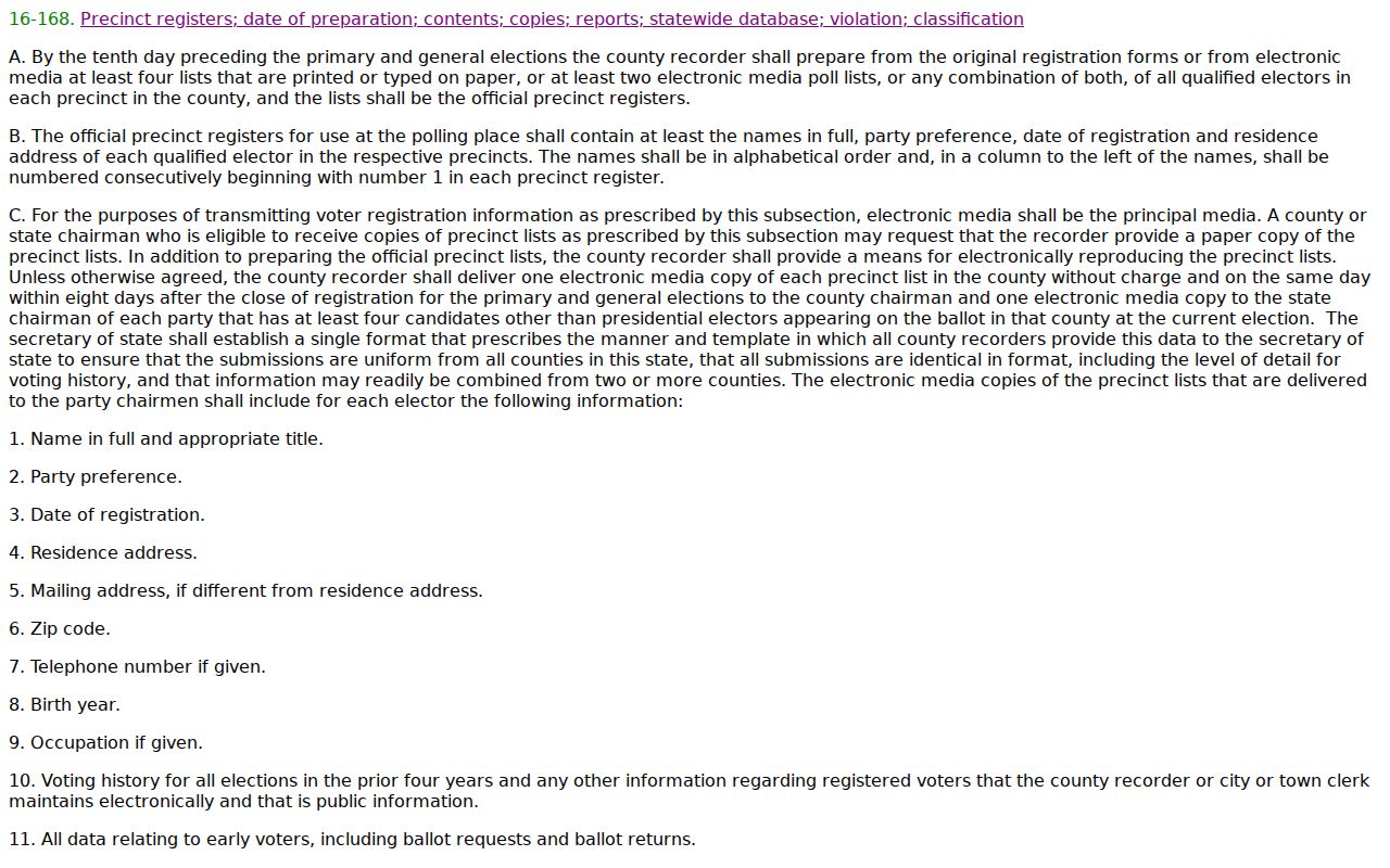
The law also keeps full birth dates, identification numbers, signatures, email addresses, and other sensitive fields restricted. Unauthorized transfer or internet distribution can be a class 6 felony. Historical Great Registers are different archival sources and can support family history without turning current voter data into a block directory.
Sierra Vista Neighbor Tool Comparison
Official and commercial search tools serve different roles. A government parcel result is tied to a named custodian and a defined assessment field. A commercial neighbor tool may blend public and purchased data, lag updates, or merge people who share a name. Neither category should be read beyond what its source proves.
| Feature | Official parcel and clerk records | Commercial compilation tools |
|---|---|---|
| Source trail | Named public custodian and record field | Mixed sources may be unclear |
| Main value | Owner, parcel, filing, legal or jurisdiction evidence | Possible leads across compiled data |
| Common error | Owner mistaken for occupant | Old, merged or misassigned identity |
| Best next step | Confirm with a second official source | Return to the original custodian |
A parcel export should win over an uncited compilation on parcel ownership, but even the official roll cannot name unfiled household members. For Sierra Vista neighbors, the most honest result may be an owner map with a clear statement about what remains unknown.
Privacy Around Sierra Vista Neighbors
Non-owner occupants, relatives, children, and other household members can remain absent from public parcel records. Utility, delivery, and DMV customer information is not a public neighbor directory. Sealed court material also stays closed. Qualifying people may use the Arizona Address Confidentiality Program, which supplies a substitute address and forwards eligible mail, while protected-person laws can redact voter and county property identifiers.
Arizona harassment and stalking laws prohibit conduct such as repeated harassing contact, following, surveillance, and directed courses that cause fear or distress. Public availability does not make harmful use lawful. When a field appears wrong, contact the custodian instead of spreading it. When an address is suppressed, respect the boundary.
Lawful use. Research Sierra Vista neighbors for civic awareness, a friendly connection, or personal curiosity. Never use an address trail to watch, harass, threaten, or intimidate anyone.